Sarez See
Sarez Lake
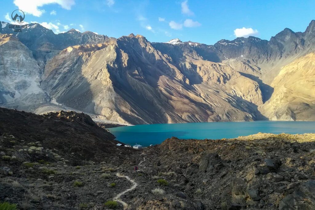
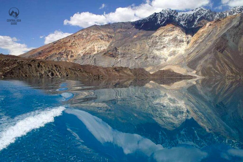
Sarez lake is one of the gems of the Pamir Mountains and is often referred to as the “Sleeping dragon”. Sarez is one of the most beautiful and mysterious lakes of Tajikistan that covers a large area of 80 sq km and is about 60 km long. The Sarez Lake lies in the deep in the very inaccessible area of the Pamir Mountains in the Gorno Badakhshan region of Central Tajikistan and is considered as one of the greatest natural wonders of Asia as it is the largest naturally rock slide formed lake in whole Asia. We offer vistis to Sarez lake as a part of some of our Tajikistan Pamir Tours. It is also possible to have a boat ride in the lake and to continue hiking on the other side or visit the weather station. A similar, much smaller but also amazingly beautiful mountain lake with a natural dam that water flows through, is the Kel Suu (Kol Tetiri) in Kyrgyzstan.
Sarez-See-Formation
Der Sarez-See entstand durch ein Erdbeben der Stärke 7,0 auf der Richterskala, das sich um Mitternacht am 5. und 6. Februar 1911 ereignete. Der folgende Erdrutsch von 2,2 Millionen Kubikmetern bildete eine riesige natürliche Barriere, die als Usoi-Damm bekannt ist. Ein Dorf namens Usoi wurde mitsamt seinen Bewohnern vollständig unter den Trümmern und Felsen begraben. Das Erdbeben verursachte auch die Zerstörung von weiteren 50 Häusern in vier anderen Dörfern der Region. Das neu entstandene Hindernis ist immer noch der höchste natürliche Staudamm der Welt (567 m, Volumen 2,2 km3). Zur Zeit des Ereignisses dauerte es aufgrund der extrem abgelegenen Lage und der schlechten Verbindungen sehr lange, bis die Nachricht an die Öffentlichkeit gelangte. Es dauerte bis zu sechs Wochen, bis die Nachricht die russischen Posten in Murghab und Chorog erreichte.
Sollte sich ein weiteres starkes Erdbeben ereignen oder wie die Einheimischen sagen: der schlafende Drache erwachen, könnte der Usoi-Damm zerstört werden oder ein teilweise eingestürzter Erd- und Gesteinskörper mit einer Masse von etwa 3 Kubikkilometern könnte in den See an seinem rechten Ufer stürzen. Die Verschiebung könnte eine Welle auslösen, die groß genug ist, um den Usoi-Damm wegzuspülen und eine Wasserwand freizusetzen, die etwa 6 Millionen Menschen überfluten könnte, die flussabwärts entlang der Flüsse Bartang, Pyanj und Amu-Darya in Afghanistan, Usbekistan, Turkmenistan und natürlich in Tadschikistan leben. Experten warnen, dass es sich um die größte Überschwemmung handeln würde, die je von Menschen gesehen wurde.


Sarez See Merkmale
Der Sarez ist einer der jüngsten Seen der Welt. Im Jahr 1913 ergaben die ersten Untersuchungen, dass der See 28 km lang, 1,5 km breit und 279 m tief ist. Seitdem wurde der Wasserspiegel um 36 m erhöht und erst 1914 schuf der Sarez-See einen Abfluss durch den Damm und gab den Startschuss für den Bartang-Fluss - einen der Nebenflüsse des Pyanj. Seitdem ist der See auf seine heutige Größe angewachsen und ist an seiner tiefsten Stelle 500 Meter tief.
Das Volumen des Sees beträgt derzeit 16 074 km3, was dem jährlichen Abfluss des Oxus (Amu Darya) entspricht. Im Jahr 1939 wurde am Ufer des Sees ein hydrometeorologisches Observatorium eröffnet, um das Wasser des Sees aufgrund der möglichen Risiken für die tiefer gelegenen Gemeinden ständig zu überwachen.


Tours Including Sarez Lake
Sarez lake legend
As very often in Central Asia, there is also a legend related to Sarez lake. According to it, the people of Usoi lived in luxury and had bad manners. They were not God fearing and therefore were punished by an earthquake. This story is to remind people to maintain integrity, hospitality, belief and live-in harmony and peace with nature in these hazardous mountainous areas.


Travel to Sarez Lake
If you are interested to visit Lake Sarez you are required to obtain a GBAO permit and a permit from the Ministry of disaster management which usually takes about 2-3 weeks. If you need the proper permissions for the lake, please get in touch with us. For processing the permit, we need a copy of our passport, a copy of your visa (depending on your citizenship), and a copy of your travel insurance. If your tour purchased from us includes a trek to Sarez lake, the permits will be handled by us.
There is no road connection to the lake, so the only way to reach it is to hike all the way to the lake. The most used Sarez trailhead is at Barchadiev village in Bartang valley which, along with nearby Savnob village has homestays. otherwise there is no tourist infrastructure here. Additionally, it isn’t easy to reach the lake as a disastrous earthquake, measuring 7,2, hit Bartang Valley in December 2015 destroying what was already a minimal slip of road and leaving 800 families homeless at the same time. Access to the lake reopened in 2017 but the way remains very rough and is only recommended for experienced hikers.
A second hiking or climbing route to Sarez can be taken by lovers of adventure and trekkers from Bulunkul, Bachor or Bardara villages. The routes from these destination merge in Wukhinch (name of the pasture) and from there it descends to Irkht and Sarez lake. The third and very least taken route comes from the Murghob side along the river Murghob that leads to Sarez.
Other Pamir sights & Destinations
Seite aktualisiert am 23.2.2023