Gissar State Reserve
Gissar State Reserve
Gissar or Hissar State Natural Reserve was found in 1983 and is located on the western slopes of the Hissar Range in Southern Uzbekistan at altitudes ranging from 1 750 m to 4 349 m above sea level. The Gissar range goes through both Uzbekistan and Tajikistan and the reserve stands at the Uzbekistan side of the border. Gissar state reserve was established when two independent nature reserves were merged. The first was Kizilsuyskiy Nature Reserve, founded in 1975 for the preservation of one of the largest juniper forests in the Western Pamoro-Alay, together with its fauna typical for this part of the Gissar Range. The second was the Mirakinskiy Nature Reserve, founded in 1976 for the protection of the upper mountain reaches and source of the Kashkadarya river and the Severtzov glacier.
The Gissar State Nature Reserve holds all of the natural complexes of the upper belts of the western Gissar range. The Gissar range ends at its eastern end by facing the impressive Fan mountains (average altitude 4,000-4,200m). The range massif is deeply cut by large watercourses and in south-west, it splits into the fan-shaped ridges of the Baysuntau system. A combination of complicated geological construction and peculiar climate has resulted in the development of a variety of landscapes. The top reaches of the Kashkadarya are one of the warmest regions of Central Asia, often considered being part of dry subtropics. There are many rivers and streams flowing into the Kashkadarya, the largest ones being the Aksu, Hanaksu, Tanhasdarya and Kizildarya. They are supplied by glaciers and water levels from these peak in the second and hotter part of summers.
The nature reserve is rich in natural features, including one of the largest caves in Central Asia – the Cave of Amir Temur in the southern part of the reserve, which is situated at more than 2,900 m. There are also cave systems in the Kyrtau range, 50 km north of the nature reserve, which are among the largest in Central Asia.
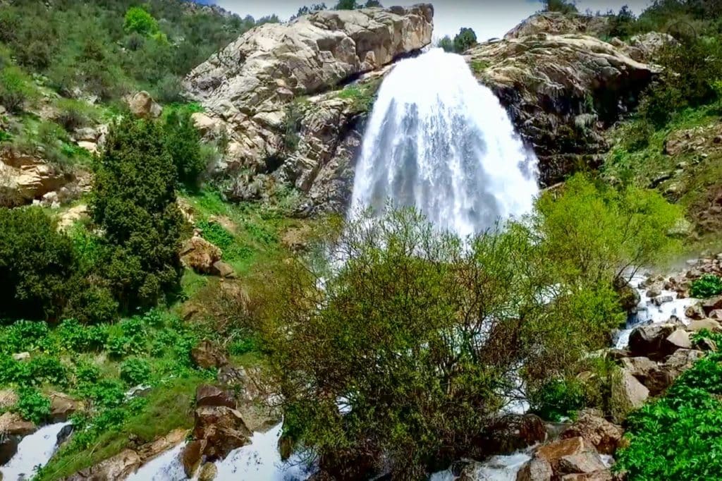
The upper reaches of the Aksu is famous for the beautiful Suvtushar waterfall and there are also smaller waterfalls in other parts of the reserve. Mature juniper forests cover less than 10% of the site, while open juniper forests and elfin woods cover approximately 20%. The flora in the park is typical for the mountains of Central Asia and has a quite rich composition. There are more than 1500 species of vascular plants that are found all over the territory of Western Hissar within the Kashkadarya region.
Amir-Timur's Cave
The cave of Amir Temur is settled almost between the village of Baysun and Shahrisabz in the Gissar mountains. Since the discovery of the cave it has brought there both historians and archaeologists and of course just curious ones. Many myths and legends are associated with this place. One of them says that after one of the lost battles Amir Temur and his soldiers retreated to the mountains. In the evening of the same day, they found a hut of a lonely old man. Because of poverty, he could not offer unexpected guests anything but flour soup. Naturally, hungry, exhausted by the road, Temur was glad even for such a modest treat. However, without waiting for the soup to cool, he quickly sipped it, and of course – burned his tongue. Noticing this, the owner said: the one who is in a hurry – loses. Temur reflected on his words. After all, he lost the last battle precisely because of haste. He asked the old man what to do in order to win. The elder replied that the soldiers did not have enough training. In addition, it was necessary to first take the surrounding villages, and only then – enter into a decisive battle. Temur listened to the words of the wise man and found a cave in which he began to prepare for the second attack taking six months to prepare.
The entrance to the cave is located in the western part of the Hissar mountains. The entry arch rises to 6 meters high and up to 7 meters wide. A huge corridor with a height of up to 10-15 meters goes deep. In the main corridor, which goes deep into the mountain for about 400 meters, there are almost no side branches and it is impossible to get lost here. The humidity level is quite high inside, the floor is covered with large boulders, and later there are several branches. In the furthest hall of the cave, there is a small lake. The lake is formed by a 10-meter waterfall falling from a crevice in the ceiling. The lake has no constant level and disappears in September-October, seeping through the rocks of the dam.
Getting to the Amir Timur cave is not easy. The adventurous trip can take three or four days and part of the border area nearby might be mined. Furthermore, numerous wild animals like leopards, bears and deer can be met here together with many rare plants. Till 2018 the cave was prohibited to visit and we do not recommend anyone to visit it without an experienced guide. Don’t forget to take a bright lantern to enjoy the magical scene of the streams of water falling into the underground cave lake.
Suvtushar Waterfall
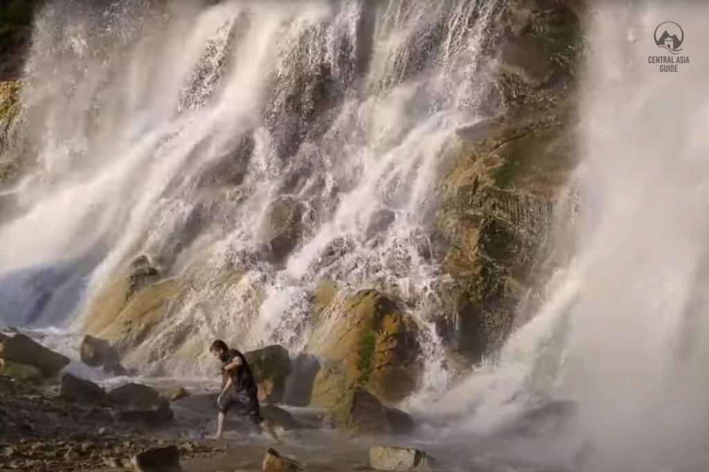
Suvtushar waterfall is a cascading waterfall located in the Gissar-Alai mountain system at the small same named river within the Gissar reserve. The waterfall reaches up to 84 m in height. The waterfall is situated in the Qashkadarya region, 8 km from the village of Suvtushar. The Suvtushar waterfall is in a small channel of the small river that originates on the slopes of the Gissar-Alai.
It is located at an altitude of 2100 m above sea level. The stream of waterfalls is located in a narrow rocky canyon with slopes that are covered with junipers. The Suvtushar River is glacier-fed and is therefore especially full-flowing during the hot summer period due to melting of the glacial ice. During the hottest summer it creates almost like a white wall of flowing water.
Other destinations & Sights near Gissar reserve
Page updated 28.5.2023