Karaganda
Karaganda
The mining town of Karaganda (or Karagandy) is the center of the Karaganda region and the fourth largest city in Kazakhstan with a population close to half a million. Thanks to plenty of natural resources and accessible location the city has grown to a major industrial, economic and cultural center of Kazakhstan, as well as an important transport hub. Karaganda region is located in the central part of Kazakhstan, among the spacious steppes and low mountains of Sary-Arka.
Geographically, the region is right in the center of Eurasia, it is equidistant from all four oceans that surround the continent. In the old days, the northern route of the Great Silk Road passed here. Karaganda is basically known for two things: coal and labor camps. The two are closely related, as the vast ‘KarLag’ network of Stalin-era camps around Karaganda was set up to provide slave labor for the mines.
History of Karaganda
The history of Karaganda is closely connected with the camp KarLag (Karagandinsky Lager). Coal mining town grew into a major industry in the 1930s when the Soviet officials decided to use the coal reserves of Karaganda to fuel the industries of the Urals. The completion of this task was achieved with the forces of convict labor of prisoners and Karaganda became famous for its high concentration of labor camps known as KarLag. In 1939 Karaganda’s population had extensively increased to 166 000 due to the forced labor being brought to the area.
Karaganda’s mines became the final stop of most prisoners who were convicted as an enemy of the nation and were sent to the KarLag labor system. Among them were many scientists, teachers and even Soviet and foreign artists, who Stalin suspected, would betray him in the war with Germany. The groups sent here included Germans, 442 000, Koreans 102 000, Polish 75 000 and peoples from Caucasus, particularly Chechens and Ingush 90 000. The villages of Uzinka (after the Russian word uznik, meaning chained prisoner) and Dolinka to the southwest of Karaganda, were originally built as prisons and inhabited mostly by convicts.
What to see in Karaganda
The city has a lot of interesting Soviet time mosaics and frescoes that have remained on the walls of the Soviet time buildings but they are slowly disappearing. The name ‘Karaganda’ is often used in a joking way in other parts of the former Soviet Union, to refer to the ‘middle of nowhere’. The express is in Russian “Gde? v Karagande (Where? In Karaganda!) It’s still a common expression in Russian. There is even a monument dedicated to this expression in Karaganda. The monument stands in the city center in the Nurken Abdirov Avenue.
Karaganda Ecological Museum
During Soviet time Kazakhstan was the center of industrial plants, mining, nuclear tests and many much more. The Ecological museum is only one in the entire CIS countries. Due to the richness of natural resources of Kazakhstan, it is going through the pressing environmental problems. By visiting the museum you can learn more about the Semipalatinsk nuclear test site, the Baikonur cosmodrome and even the crashes of space rockets.
- Entrance fee: 200 tenge. English-language guided tours available.
- Buqar-Jyrau Avenue 47, Karagandy 100000, Kazakhstan
- Working hours: Mon-Fri 9.00 - 18.00
Sights Around Karaganda
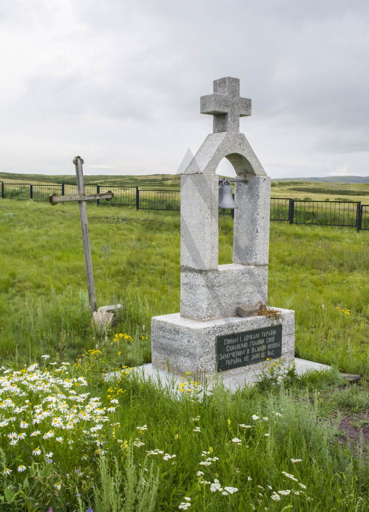
Spassk memorial to victims of repression
There is a group of monuments to the many nationalities who died in the KarLag camps on the way from Karaganda to Balkhash, 36 km south from Karaganda. It includes a collection of memorial stones and the monuments are lined up at the northern end of a fenced open field that can be seen as a cemetery or a mass grave with unmarked graves.
They are all of a quite individual design, some more traditional, others quite unusual. They have been erected here by or on the behalf of the governments of the various nations that the camp’s prisoners had come from. In addition to the former Soviet republics, there are also memorials from Germany, Poland, Japan, Finland, Korea, France, Italy and Romania.
Chechen Village
During the frozen winter in 1944, Chechen people were taken to Kazakh steppes in the cold cargo railway carriages. It was mass-deportation ordered by Stalin for forced labor. On the way, trains stopped to throw the bodies of those who could not bear the road. The few survivors were allowed to return to their home only in 1957. Today, more than 70 years later, the descendants of the deported Chechens, call Kazakhstan their homeland. They were able not only to build a new life here, in the middle of the steppe, but also prevailed in preserving their national traditions. The Chechen village of Krasnaya Polyana is located about 100 km south from Karaganda.
Temirtau City
Temirtau is the center of Kazakhstan’s iron industry and the home to the country’s biggest steel production plant – Karaganda Metallurgical Combine. It is located 40 km north of Karaganda, at the bank of the Nura River. The town started as a Zhuar first, but it was renamed to Samarkand and damming of the Nura River created the Samarkand Reservoir in 1930 which provided a stimulus to industrial surroundings.
In spite of the charges about air quality and low wages from the residents, the locals are proud of working in the factories. The factories still remain to be the essential part of Kazakhstan’s heavy industry. Temirtau is also known from the fact that it is the place where the young Nursultan Nazarbayev began his career in the Communist Party.
From the point of view of a tourist, Temirtau is mostly interesting for those willing to see the normal lives of local people working in a large industrial complex. Even the monuments in the city are related to metallurgy. Temirtau is located about 30 kilometers north from Karaganda.
Zangyrtas Petroglyphs
Zangyrtas are incredible drawings on ancient stones, made by artists of the Bronze Age. These witnesses of history are lined up along the ridge of a hill located 20 kilometers northeast of the village of Ulytau. The drawings contain mainly animals, including saiga, which is now on the verge of extinction. Zangyrtas stones have an unusual feature – when you hit the stones they release musical sounds of different tones.
Note that the Zangyrtas petroglyphs are a 665 km drive away towards southwest from Karagandy.
Begazy Burial Ground
The Begazy burial ground is an archaeological treasure of the Karaganda region. The complex includes a large number of burials from different times. Of particular interest are the grave structures made of stone where huge stone slabs weighing up to three tons were used in construction. The Begazinsky monuments are one or two-chamber buildings of a square shape, the sides of which are strictly oriented to the cardinal points. During the excavations, fine household items were also discovered but they are now kept in several archaeological museums.
Travel to Karaganda
Plane
Daily flights are flow by Aeroflot Airlines from Moscow and Astana Airlines and SCAT Airlines fly from Almaty. There are also flights from Oskemen by SCAT twice a week.
Saky Arka Airport of Karaganda is located 22 km southeast from city center. The best way get to the town is by taxi and one way trip will be about 2000 tenge.
Train
Karaganda stands on the mainline between Nur-Sultan (4 h) and Almaty (11 h by overnight train).
The railway station is located centrally in the southeast on the intersection of Bukhar Zhirau and Ermekov Streets.
Bus
There is a daily bus from Nur-Sultan to Karaganda, which departs from Nur-Sultan bus station. The buses are quite comfortable and often have a TV. The trip lasts 3,5 – 4 hours.
Other sights near Karaganda
Page updated 16.3.2021