MANGYSTAU
Mangystau
Mangystau (or Mangyshlak peninsula) is a land of fantastic landscapes where you can feel like you are on Mars or at the bottom of the sea (where you actually are). This place would be perfect to shoot fantasy genre movies as the landscape is truly extraordinary with underground mosques and poems painted in the rocks. Mangystau is located in the Southwest part of Kazakhstan, at the shore of the Caspian sea and just next to borders of Uzbekistan in east and Turkmenistan in south. Lately the region has become the rising star of Kazakhstan’s tourism sector as flocks of people arrive to admire the amazing views during Mangystau tours.
According to the latest evidence, the Caspian Sea’s water level was as much as seven meters lower between the fifth and 14th centuries, than it is today and there was a land bridge between Mangyshlak area and the Caspian Sea’s north shore. Caravans were thus able to pass through this shortest route to Itil on the Volga River. The areas of old caravanserais can still be seen in the area next to the watering holes, that form green islands in the otherwise barren landscape.
Mangystau area is very dry, not having enough fresh water for most plants and therefore has only low vegetation. This means that the peninsula is a mostly uninhabited, deserted area. The area of the Mangistau region is about 165 000 square kilometers, the population is 650 thousand people which means that there are only 3,5 inhabitants per square kilometer. However, the area is very rich with minerals and it is called the “treasure peninsula” due to the variety and abundance of raw materials. The region also owns a quarter of all oil in Kazakhstan together with the richest deposits of uranium that were discovered in the 1950s. In addition, it is one of the main regions in the world where strontium is found widespread.
Mangystau holds a lot of important sites of pilgrimage like mausoleums and a number of underground meditation chambers (retreats) used by famous Sufi figures of the past. They are commonly defined as mosques (islamification) because of their sacred nature and the rock-hewn rooms in which pilgrims pray in.
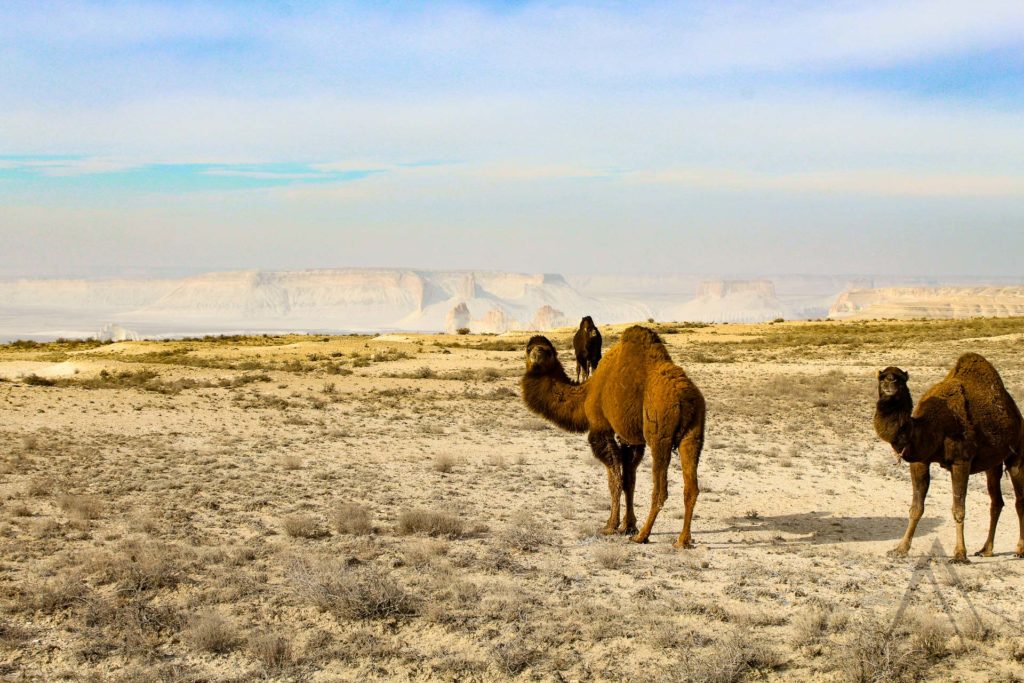
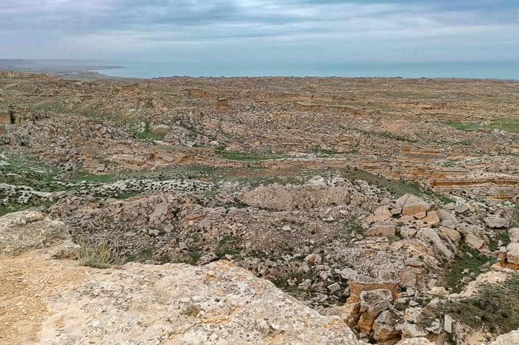
Mangustau is really a place for people who enjoy geological formations but also offers things to see for the nature lovers with the abundant bird life at the shores of the Caspian Sea and also the ancient life that has lived in the area when it was the bottom of the sea, can be seen in the fossils laying around in the area. Bear in mind that the destinations in the area are often far away from each other and you will spend most of your time driving around from one sight to another but they are worth it and the views during the car drives are an experience as themselves.
Mangystau sights
Table of Contents
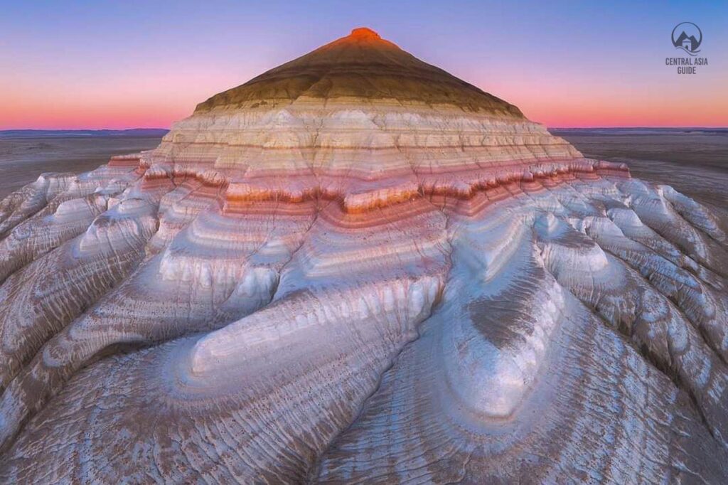
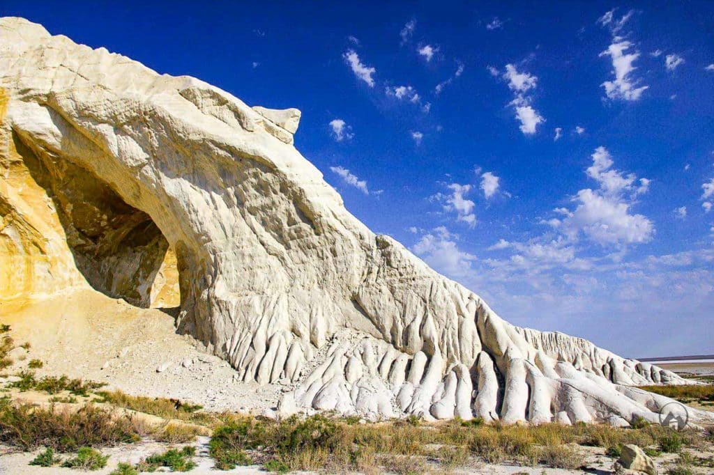
Sherkala Mountain
Sherkala “Mountain” rises to the height of 307,7 m and is called “God’s yurt” by the locals, perhaps because it has a distinct form of a space object. Sherkala is the most recognizeable sight of Mangystau and it can take about half a day to get around the mountain completely but it is worth it as Sherkala has different shapes on each side. From one side you can clearly see the shape of the yurt and on the other side the shape reminds a powerful resting lion. There are plenty of legends that are associated with the mountain. According to one of them, a group of warriors defended themselves at the top from a myriad of enemies.
The adventurers fought like lions, but because of the numerical superiority, they began to suffer defeat. Trying to flee from their enemy they hid in the underground passages of the mountain and remained forever in its womb. In Sherkala there are many other mysterious dungeons as well. On the northern part of the mountain, there are the remains of ancient settlements – small grottoes of artificial origin, below the approaches to the settlement were guarded by a wall of cobblestones.
Not far from Sherkala mountain, you can see the remains of an ancient city. Once it stood on one of the branches of the Silk Road that passed through the peninsula.
Caravan routes went from Bukhara and Khiva to the Caspian Sea and merchants reached Europe by sea or further land routes. The history of the appearance and disappearance of this settlement has not yet been revealed, but scientists believe that it was a rather rich city and do not exclude that many valuable finds are still hidden in these places.
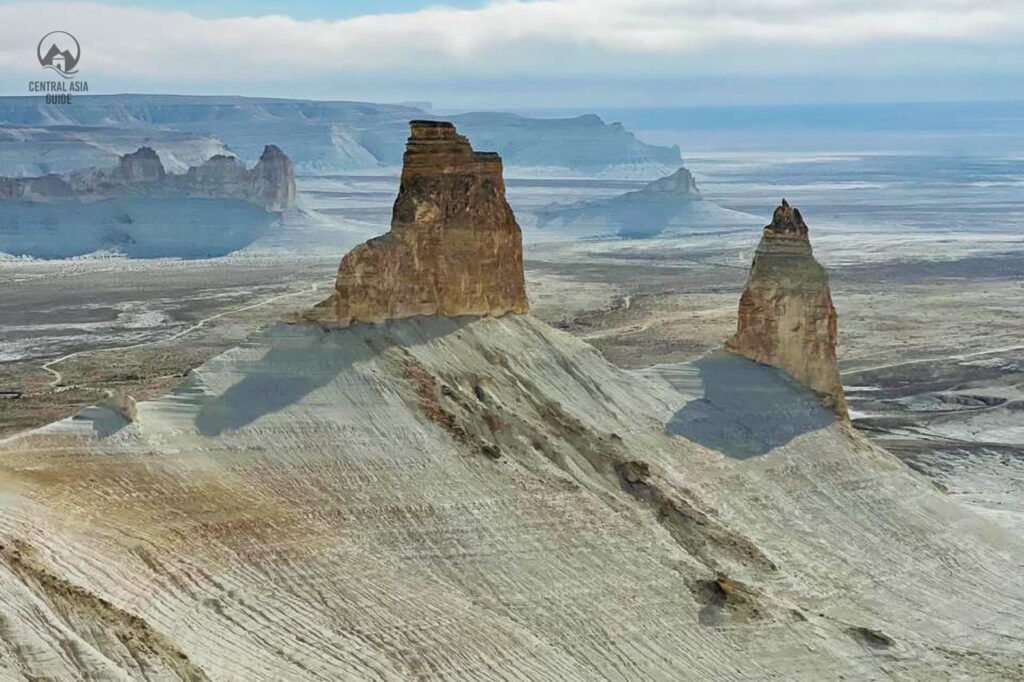
Boszhira Tract
Boszhira tract (Bozjyra) is the flatland covered with sharp rocky peaks shining in the sunlight. Hundreds of millions of years ago this place formed the bottom of Tethys, the ancient impetuous ocean of the Mesozoic era. The unique landscape has formed as a result of continuous change of the ocean’s water level.
White stones, perfectly carved by time, and sea remains are scattered throughout the valley. On the top of the plateau, one can easily observe stony installations made of limestone plates. All around is white here canyons, peaks, mountains-towers, mountains-castles and mountains-yurts. Boszhira tract lies in the western part of the Ustyurt Plateau, on Mangyshlak Peninsula. The distance from Aktau to Boszhira is about 300 km.
Mangyshlak's Sacred Caves
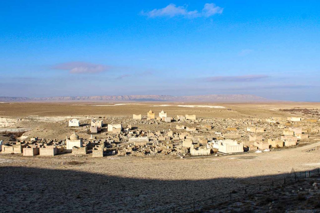
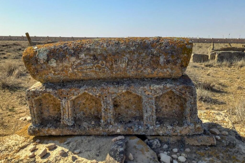
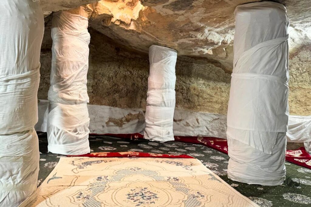
There are many cemeteries, mosques and places of pilgrimage here and it is the reason why Mangyshlak is considered a holy and sacred land within Kazakhstan. In Mangystau you will find hundreds of necropolises in addition to “underground mosques”, which are always coupled with a tomb of a saint and huge cemeteries.
There are around 15-20 underground mosques on the peninsula all connected with the graves of local Sufi saints (362 saints are buried in the region, almost one for every day of the year), with cemeteries generally dating from the 9th to 19th centuries AD.
They serve as an important destination of pilgrimage across the peninsula, the most visited ones being from West to East: Shakpak-Ata, Sultan-Epe, Karaman-Ata, Shopan-Ata and Beket-Ata being the most known. Some of these mosques have been dated to the period of the earliest tombs 9th- 10th centuries AD and are attributed to different peoples, listed in chronological succession: Khazar, Oguz, Kypchak, the Golden Horde, the Nogai Horde and Kazakh.
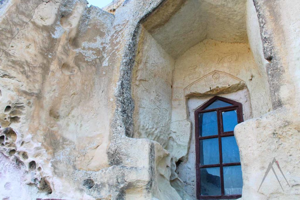
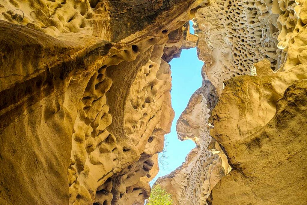
Shakpak Ata Underground Mosque
The Shakpak-Ata Mosque is an underground mosque located on the Tyub-Karagan peninsula 90 km North of Aktau on the cliffs of the Northwestern top. It dates back to the 9th-10th century AD and is considered the oldest one in Mangyshlak. The idea of Shakpak-Ata is unique in Mangyshlak and presents similarities with some early Persian mosques and with the mausoleum-mosque of Shir-Kabir in Dehistan, Turkmenistan which is also dated to the same era. Another unique feature of this underground mosque is that large portions of its walls are covered with petroglyphs and graffiti.
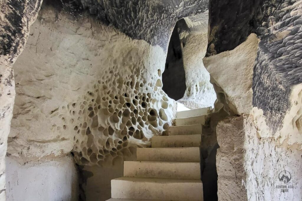
Legend says that Shakpak-Ata was the grandson of Shopan-Ata. He was an ascetic dervish who took refuge in the cave with his disciples at a time when enemies were assaulting the region.
He spent the last years of his life as a hermit never leaving the cave. It is also said that the ancient Sufi masters gave asylum to sick people in their underground shelters to heal them and that even today a night spent in these caves in the company of benevolent spirits will cure most diseases.
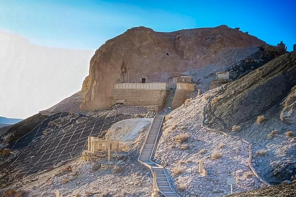
Beket-Ata Underground Mosque
The Beket-Ata underground mosque is one of the most sacred pilgrimage sites in Kazakhstan, located in the Mangystau region. It was founded in the 18th century by Beket-Ata, a revered Sufi mystic, philosopher, and teacher, who dedicated his life to spreading Islam and educating followers. Known for his wisdom and miracles, Beket-Ata built several mosques throughout the region, but this underground sanctuary, carved into limestone rock, is considered the most significant.
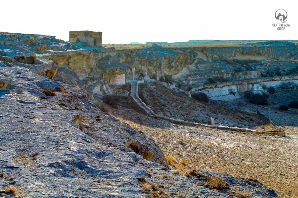
The mosque is nestled in the remote Oglandy Valley, surrounded by stunning desert landscapes and rocky formations.
Pilgrims and visitors must descend a winding path to reach the sacred site, where a peaceful atmosphere fills the ancient chambers. Many believe the mosque holds spiritual power, and people visit to pray, seek blessings, and pay respects at Beket-Ata’s final resting place.
A journey to Beket-Ata is not just a physical trip but also a spiritual experience. The site attracts believers, historians, and travelers drawn by its deep history, breathtaking scenery, and the legend of Beket-Ata, who remains a symbol of faith and enlightenment in Kazakhstan.
Karaman-Ata Underground Mosque
The Karaman-Ata Underground Mosque is a sacred and historical site located in the Mangystau region of western Kazakhstan. This mosque, like several others in the region, is carved directly into the cliffs, creating a spiritual and atmospheric place of worship that is deeply intertwined with local history and culture. The mosque is named after Karaman-Ata, a revered Sufi figure and teacher in Central Asia, who is believed to have lived in the region centuries ago and played a key role in spreading Islam across the steppe.
The underground mosque is a unique blend of natural and spiritual elements. It is carved into soft limestone or chalk cliffs, with a series of interconnected rooms and passageways forming the mosque’s interior. The rooms often feature simple, unadorned spaces, with small niches and altars carved into the rock for religious purposes. The atmosphere within is cool and serene, creating a peaceful setting for reflection and prayer. Visitors to the mosque are often struck by the simplicity of the structure, which stands in contrast to more ornate, surface-level mosques.
Historically, these underground mosques served as places of refuge for Sufi pilgrims and religious leaders who sought to escape persecution or harsh climatic conditions. Karaman-Ata, like many other spiritual figures of his time, chose this remote and harsh environment to practice and teach, believing the solitude of the desert offered a perfect setting for spiritual contemplation and growth.
Today, the Karaman-Ata Underground Mosque remains a pilgrimage site, attracting both local worshippers and tourists. It is part of the rich spiritual heritage of the Mangystau region, which is dotted with similar underground mosques, mausoleums, and sacred sites. The surrounding landscape, a vast and stark desert, only enhances the mystical atmosphere of the mosque, making it a powerful reminder of the region’s deep connection to Sufi traditions and Kazakhstan’s broader Islamic history.
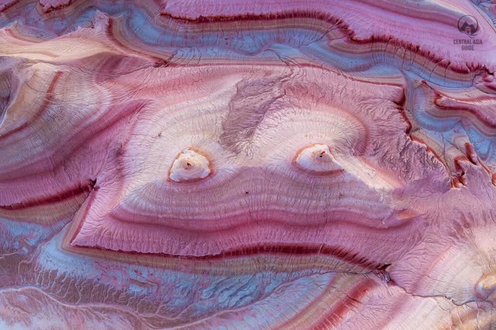
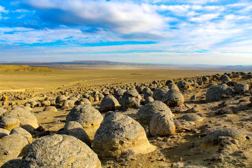
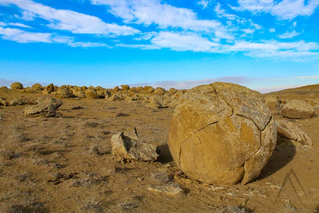
Torysh Balls Valley
Peculiar round stones (Devil's balls)
The Valley of Balls or in Kazakhs known as Torysh, is home to peculiar round shaped rocks that seem like they would have been rolled to their form by giants while playing with clay or dough. Some even call them the devil’s balls. It consists of numerous ball-like rock formations strewn across a wide range of steppe land. The balls range in size from tiny marble-like rocks to huge boulders the size of a car. Torysh is a part of the Torysh tract.
Legend has it that when the Mangystau region of Kazakhstan faced countless attacks by enemies, the locals appealed to the heavens for help. Their prayers were answered, and the invaders were turned into giant stones.
The phenomenon is poorly researched, however, the scientist believes that the “balls” most likely date from the mid-Jurassic to the early Cretaceous period (180-120 Ma). They are perhaps made of either silicate or carbonate cement. Most geologists who have examined them have said that they are giant concretions, though fringe thinkers say that these balls were made by extraterrestrials or ancient, technologically advanced humans. Furthermore, some researchers believe that these globular rocks are remnants of meteorites that crashed and landed on earth. Others theorise that they are giant concretions, a word derived from the Latin word “concretio”, which means thickening.
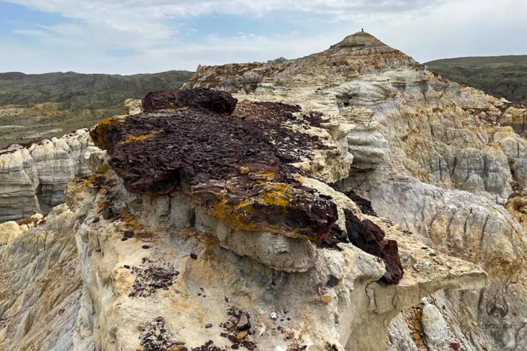
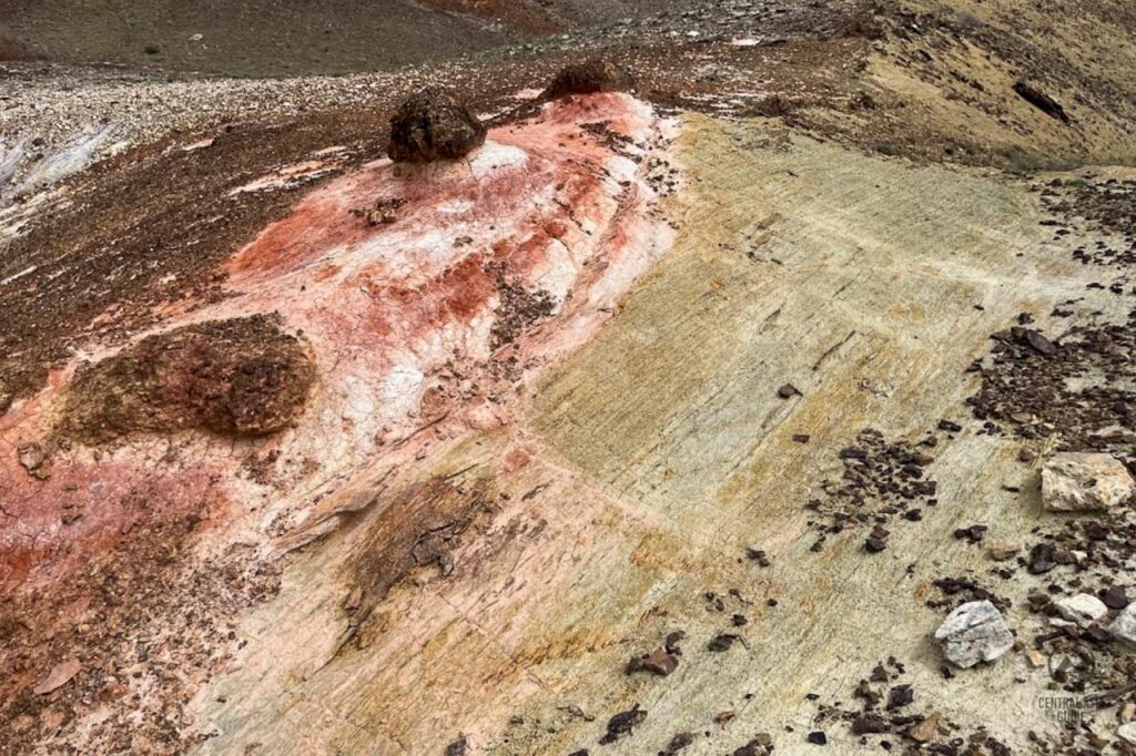
Kokkala Jurassic formations
The Kokala tract is located between two ridges in the northwestern part of the Western Karatau ridge and in the central eastern part of the Northern Aktau ridge, not far from the village of Shayyr and the Mount Zhalgan and just south of Mount Sherkala. The Kokala tract is famous for its bizarre washouts of variegated and colored clays and a mountain gorge with spring water, which is located in the immediate vicinity of the tract. The Karatau mountain fold, rising from the bowels of the Earth, lifted layers along the edge of the fault, which were forever buried under the thickness of oceanic sediments. This is how colored clays of the Jurassic period were born. Kokala is a natural multicolour among the monolithic rocky highlands of Mangystau, a small temporary tunnel in the age of dinosaurs.
In Kokkala you will not find fossilized remains or traces of long-gone reptiles, but you can touch real wood deposits and the coals of a burnt forest on which dinosaurs roamed. We will not see fossilized bones or traces of long-vanished reptiles here, but we can touch real charcoal 170-200 million years old from the burnt forest where dinosaurs roamed. Nature has surprisingly eroded the layers of clay, creating a layered mountain of hummocks, columns, mushrooms, pyramids and miniature canyons with bizarrely incised sides. Kokala is a natural variegated color among the monotonous rocky mountains of Mangystau.
Airakty Valley of Castles
Airakty-Shomanai or simply Airakty is a system of remnant mountains on Mangystau. They became known under the name “Valley of castles of
Airakty” thanks to the drawings of the Ukrainian poet Taras Shevchenko. The surroundings of Airakty resemble a mysterious desert city with ruined remnants that look like towers and castles with spires. It is recommended to climb the mountain and get a better view of the terrain from a flat platform. You can also see the Aktau Mountains from it. Walking along the path to the site, you can meet steppe horses and mouflons, and at the foot of the mountain – scorpions and tortoises.
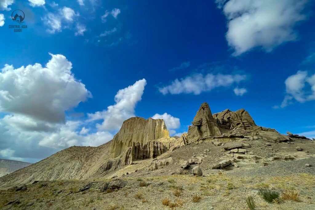
Like the Bozzhira tract, the Airakta Mountains were covered by the Tethys Ocean in ancient times. This is why the Mangyshlak peninsula is interesting, which was formed 25 million years ago as a result of a layer of the earth’s crust that rose due to an earthquake. After that, the
formation began to deviate to the west. Over time, the erosion of the Cretaceous rocks led to the formation of canyons, outliers, caves, and winds and precipitation completed this process.
To this day, the landscape is changing. Presumably, after 5-7 thousand years, weathering will lead to the disappearance of the remnant mountains altogether, since their height decreases every year. Since the end of the VI century, caravans of the Great Silk Road have been passing through the land of Mangistau, and legends say that treasures can be found in the valley. Tourists often come with metal detectors in order to find gold. According to local shepherds, sometimes they actually find silver and gold coins.
Mangystau Tours
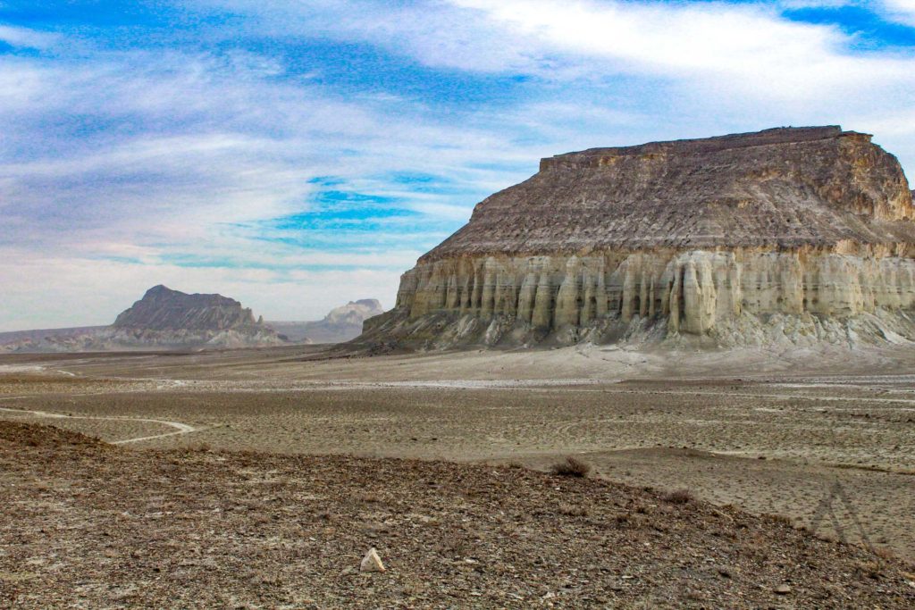
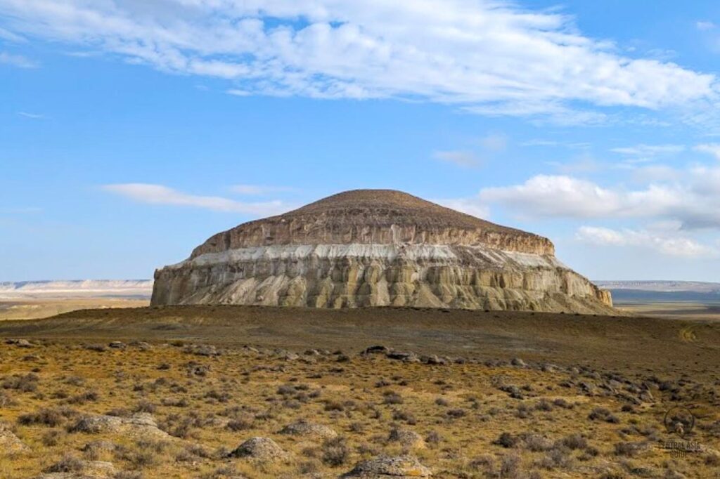
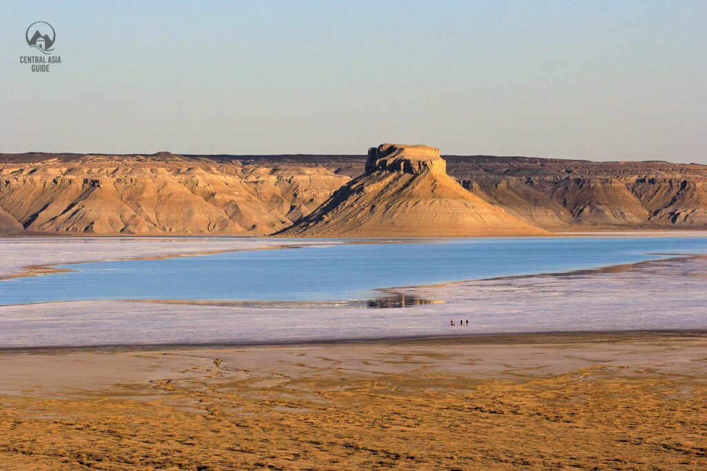
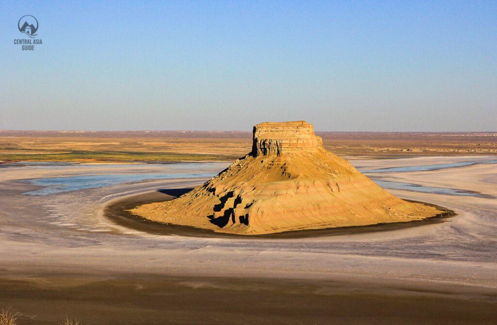
Tuzbair salt flat
The main attraction of Tuzbair is the salt marsh of the same name. In Kazakh, it is called “sor”, which means a kind of salt marsh that has no runoff and is shallow. Sores are formed in depressions no more than one and a half meters deep. During the spring melting, the salt marsh is covered with a water surface, in which the sky is picturesquely reflected. In the summer, the crust freezes and you can walk freely but occasionally your feet might still fall into salt water deposits to a depth of 10-15 centimeters. Therefore, to walk on the surface of the salt marsh, you need to wear rubber boots or other waterproof shoes with a high boot or to walk barefoot. Some tourists believe that a warm salt crust has a beneficial effect on the body. You can’t drive through the salt marsh by car as the crust can’t stand the weight of even a passenger car. Every year, cars get stuck in the marshy area of the salt marsh.
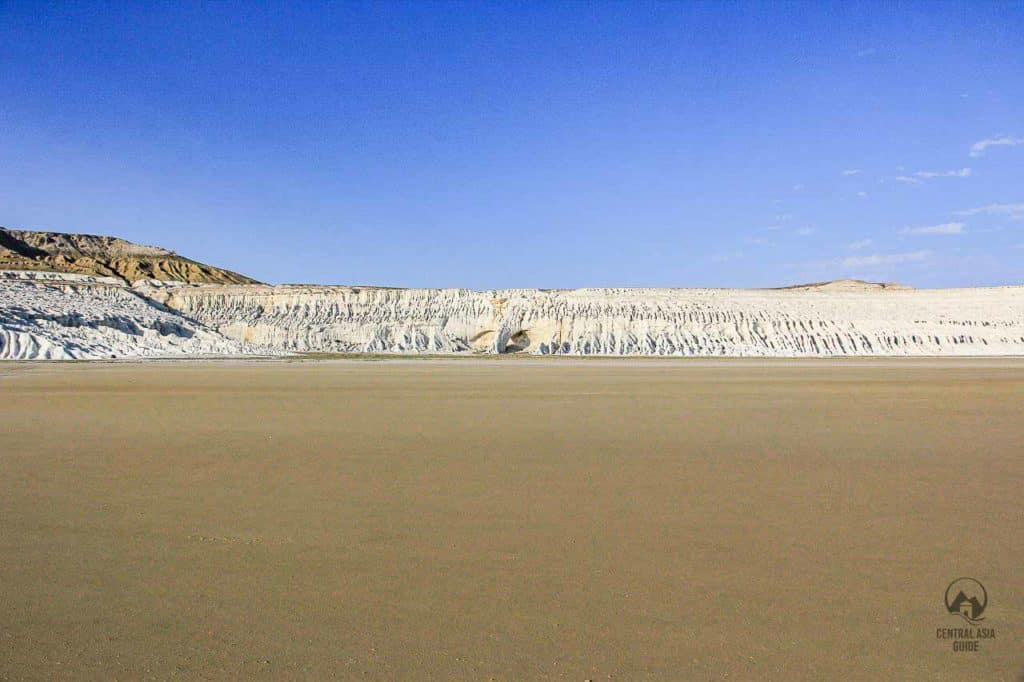
You can drive here by car only with local guides who know proven trails. According to scientists, today’s Mangystau region was once the bottom of the Tethys Ocean, located between the supercontinents of Laurasia and Gondwana, about 250 million years ago. This is evidenced by the skeletons of sharks and their teeth, which are sometimes found in this valley. Over time, as the water receded, the combination of wind and rain shaped the landscape, creating beautiful sculptural chalk cliffs, cliffs and depressions. It is believed that Sora Tuzbair, along with plateaus, gorges and ravines, was formed as a result of erosion of softer rocks.
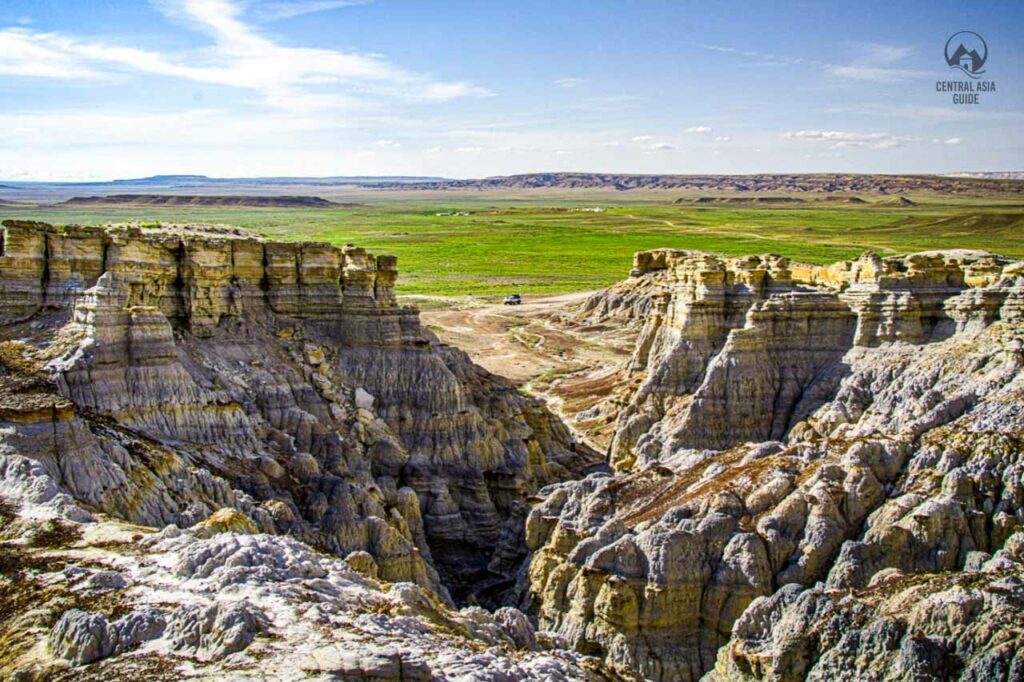
Ybykty Sai
Ybykty Sai Canyon, located in the Mangystau region of western Kazakhstan, is a hidden gem that showcases the rugged beauty and unique geological formations of the area. The canyon is also known as Porous Gorge Ybykty due to the porous nature of its rock formations, which have been carved over centuries by wind and water erosion, resulting in a dramatic and intricate landscape.
This canyon is notable for its towering cliffs, narrow gorges, and the winding paths that reveal layers of sedimentary rock in a variety of colors, from pale whites and yellows to rich reds and browns. The diverse shapes of the rock formations give Ybykty Sai a surreal appearance, with sharp ridges, pillars, and natural arches formed by the elements over time. The porous texture of the rock gives it a sculpted look, adding to the canyon’s distinctive character.

Ybykty Sai Canyon is also relatively remote and less frequented by tourists, making it an ideal destination for those seeking solitude and an authentic experience of Mangystau’s wild landscapes. The surrounding desert adds to the canyon’s stark beauty, and visitors are often struck by the contrast between the flat desert plains and the dramatic rock formations within the canyon.
The Ybykty Sai area is also rich in biodiversity, with a variety of plant species adapted to the arid conditions, and it serves as a habitat for several species of desert wildlife. For adventurers and nature enthusiasts, the canyon provides excellent opportunities for hiking, photography, and exploring the unique geology of Mangystau. The combination of natural beauty, isolation, and geological significance makes Ybykty Sai Canyon a must-visit for those exploring Kazakhstan’s remote treasures.
More Tours to Mangystau
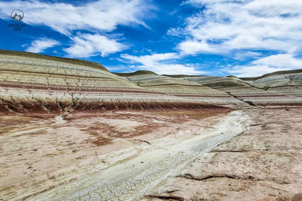
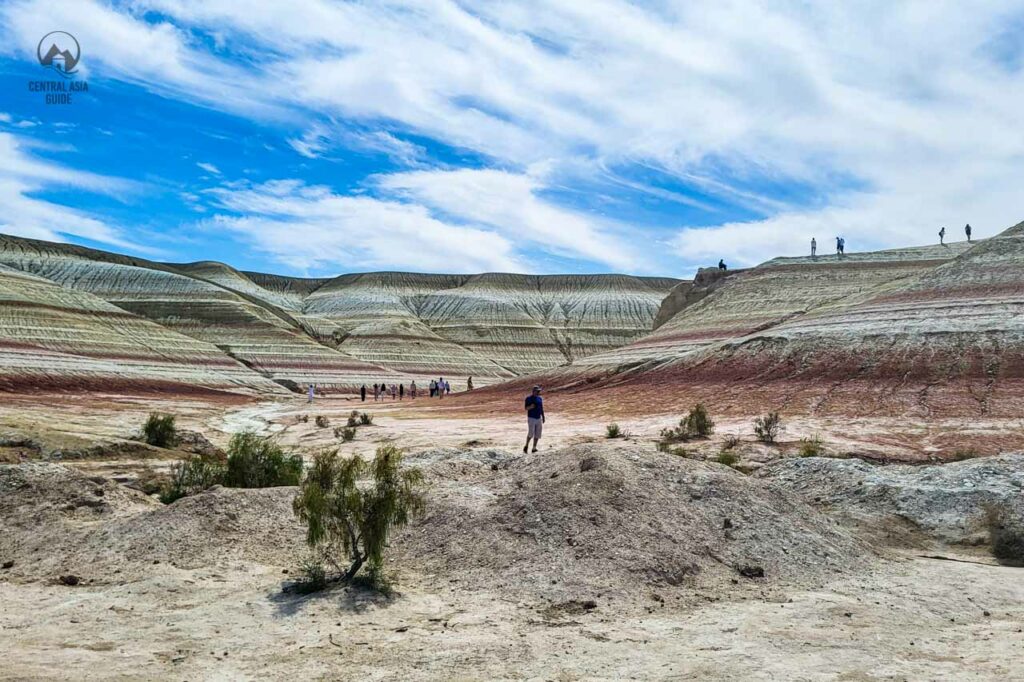
Kyzylkup Tract
The Kyzylkup tract is smooth low hills composed of rocks of various colors that alternate with each other, creating a fascinating spectacle. The color of the layers is given by impurities of various minerals. The white layers consist of chalk, and the red ones contain iron. Because of its unusual layered structure, the tract is often called “Tiramisu” by the people.
The official name of the tract was received from a reservoir, which was once located nearby. The Ustyurt plateau used to be the bottom of the ancient Tethys Ocean. And there was a constant accumulation of precipitation on it: clay, sand, various organisms. Therefore, it is not surprising that landscapes change their colors at different times of the day. During the day, in sunny weather, the landscape is snow-white, in the evening it acquires cream shades, at sunset it turns purple.
Over centuries, wind and water erosion have sculpted these layers into intricate shapes and patterns, resulting in a canyon landscape that’s as beautiful as it is dramatic. The soft, crumbly appearance of the rock formations combined with the vastness of the canyon provides a mesmerizing experience for visitors. The geology of the area reveals its ancient past, with each layer representing different eras of sediment deposition, and the canyon stands as a natural timeline of Mangystau’s geological history.
Hiking or driving along the Kyzylkup Track to Tiramisu Canyon offers an incredible opportunity for photography, and the quiet, untouched nature of the area enhances the sense of adventure. For those exploring Mangystau, the Tiramisu Canyon is a visual highlight, encapsulating the region’s unique blend of rugged desert terrain and natural artistry.
Zhygylgan Fault / Fallen Earth
Zhygylgan Fault is a geologically fascinating site and a must-visit for those interested in natural wonders. Often referred to as the “Fallen Earth,” Zhygylgan is a massive depression or sinkhole created by the collapse of a limestone plateau. Over millennia, tectonic shifts and erosion have shaped this unique landscape, giving rise to dramatic cliffs, caves, and rock formations.
The fault spans a large area along the northeastern shores of the Caspian Sea, and its cliffs drop steeply into the sea, creating an otherworldly atmosphere. The area is dotted with large boulders and broken rock slabs, which have tumbled down from the plateau above. These formations, combined with the surrounding flat desert, make for a striking visual contrast. Some of the rock formations bear ancient petroglyphs, adding historical significance to the site.
Local legends often describe Zhygylgan as a mystical place, with stories of ancient battles and myths of giants contributing to its allure. It’s also home to archaeological remains, including fossils and ancient artifacts, which suggest that the site was used by early humans. Visitors to the Zhygylgan Fault not only get to witness a unique natural phenomenon but also step into a landscape rich with geological and historical significance.

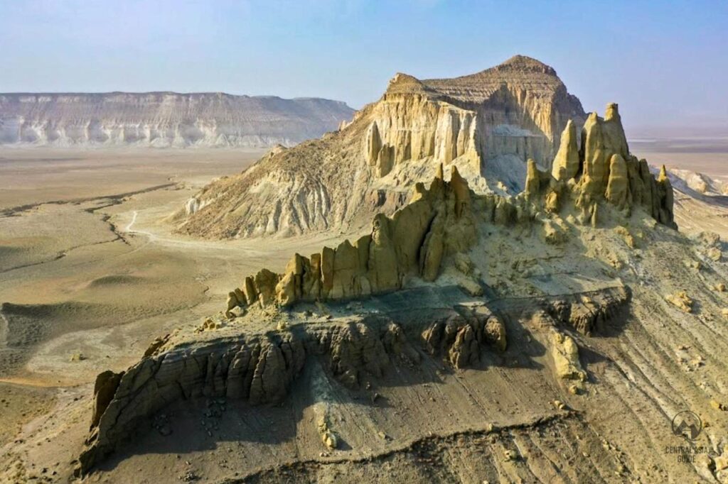
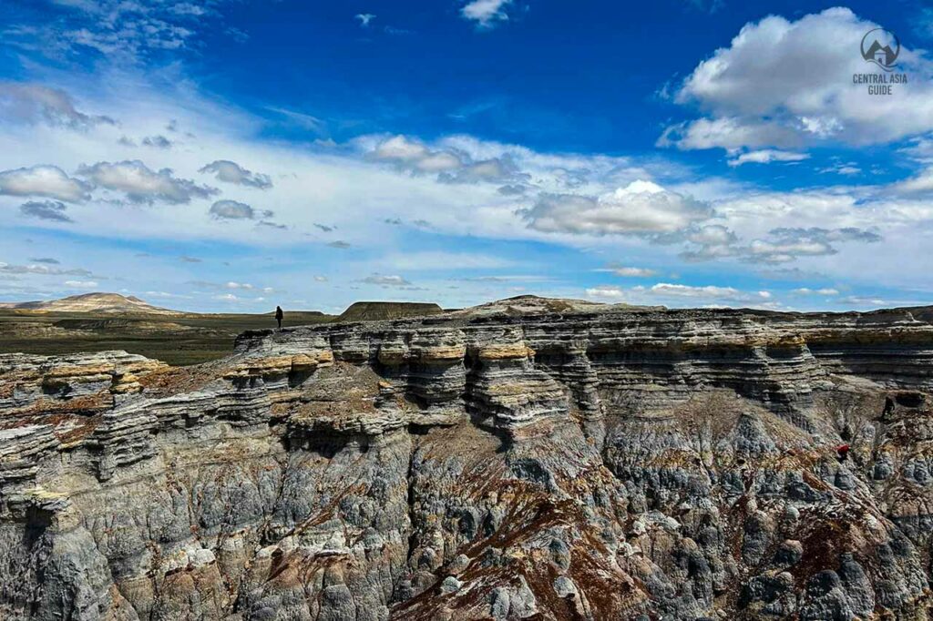
Karynzharyk Depression
The Karynzharyk Depression in the Mangystau region of Kazakhstan is a vast and visually striking landscape, known for its immense salt flats, towering chalk cliffs, and unusual geological formations. This depression is located in the southwestern part of the Ustyurt Plateau and descends to one of the lowest points in the region, making it an iconic feature of Mangystau’s rugged, otherworldly terrain.
At the heart of the depression is a massive salt pan, often dry and shimmering under the sun, but during wet periods, it transforms into a shallow lake, adding to the surreal beauty of the landscape. The white salt surface contrasts dramatically with the surrounding flat desert plains, creating a stark, almost lunar atmosphere. The depression is flanked by high chalk plateaus and mesas, which have been carved by wind and water erosion over millennia, giving the region its jagged, sculpted appearance.
One of the most distinctive features of Karynzharyk is the presence of five prominent buttes or isolated rock formations, often referred to as “islands,” that rise abruptly from the flat salt plain. These formations, known locally as “islands of Karynzharyk,” are breathtaking to behold, particularly when viewed from above or from the rim of the depression, as they seem to float on the salt flats.
Karynzharyk also holds cultural and historical significance. The area has been inhabited by nomadic peoples for centuries, and remnants of their presence, such as ancient petroglyphs and burial sites, can be found throughout the depression.
The remoteness and isolation of Karynzharyk make it a perfect destination for adventurers seeking to experience the raw, untouched beauty of Kazakhstan’s landscapes. The depression offers an unparalleled opportunity for photography, hiking, and off-road exploration, with its vast, open spaces and striking geological formations offering a sense of solitude and wonder.
KOKALA - Jurassic clays
Kokala, also known as the Kok-Kala Tract, is a captivating geological site located in Kazakhstan’s Mangystau region. This small gorge is renowned for its vibrant, multicolored clays and rocks that date back to the Jurassic period, approximately 170-200 million years ago. The striking hues result from layers of limestone, clay, and ancient sediments that have been uplifted by tectonic activity and sculpted by natural erosion over millennia.
Mangystau History
The region’s natural wonders were born at the ear of the ancient Tethys Ocean, which spanned the Earth for a billion years. Today, when you look closely at the foundational layers of the enormous limestone formations of Bozzhyra and Airakty, you’ll find mysterious patterns and designs that were once marine life of the Tethys Ocean. Shell remnants, some located over 200 kilometers from the Caspian Sea, and fossils like prehistoric shark teeth and ichthyosaur bones, from the Mesozoic era.
After the ocean retreated, dinosaurs roamed, later giving way to the age of mammals. In Mangystau’s Zhygylgan depression, you can find ancient footprints of predatory mammals and various birds, all pointing to the Miocene epoch. Ancient human traces found near the Caspian Sea coast suggest continuous habitation from the Paleolithic to Neolithic periods, indicating human presence here about 12 000 years ago. Notable sites include the area near Shakpak-ata and the Kulaly Island settlement.
Portions of the famed Silk Road passed through Mangystau, as evidenced by ruins of caravanserais, fortresses, and mosques. Yet, its harsh desert climate meant that not all ventures dared to traverse the vast stretches of the Ustyurt Plateau. The region’s first historical mention is from the 9th century by Arab geographer Al-Istakhri, referring to the land as Siyah-Kuh (“Black Mountain”). Yet, after Genghis Khan’s invasion, this route was abandoned, causing Mangistau to fade from historical records.
It wasn’t until the 18th century, amid Russia’s Central Asian conquests, that Mangystau re-emerged as a pivotal point. It became a stronghold for Russian military expeditions heading south. A series of name changes for key forts in the area culminated in Fort Shevchenko, named in honor of the renowned Ukrainian writer and poet Taras Shevchenko.
The 20th century ushered in a new chapter for Mangystau when vast uranium, oil, and gas reserves were unearthed. Rapid industrialization followed, with the region boasting some of Kazakhstan’s highest wages. Aktau is now celebrated as Kazakhstan’s oil capital.
Travel to Mangystau
Aktau is the usual starting point for tours in the region. Aktau can be reached by train or airplane. From Aktau you can take a car or join a tour. The best times to visit are autumn and spring since in the summertime the temperature can rise up to more than +40 C making the travel in the area fairly uncomfortable.
Other sights near Mangystau
Page updated 14.1.2025