Day 1. Osh – Tulparkul-lake (7-8 hours of driving including stops)

After flying into Osh, Kyrgyzstan, heading to Sary-Mogol, a village which offers the best views of Lenin Peak (7134 m). Half day or so walk to base camp peak Lenin and back, around beautiful and unbelievable landscape of Tulparkul Lake. Overnight in yurt in Tulpar Kul Lake camp. 260km
Meals: B/L/D
Altitudes above sea level during the day: in the beginning of the day – 950m Osh. At end of the day – 3500m Tulpar Lake.
Day 2. Tulparkul-lake – Karakul lake – Murghab (10-12 hours of driving)

Driving towards the biggest lake in Tajikistan – Karakul via Bordeba-Kyzyl-Art, Kyrgyz-Tajik border check point. Hiking along the Karakul Lake. In the afternoon continue driving to Murghab via the highest pass in former Soviet Union, Ak-Baital (4656m). Short stop near the first Tsarist Russian military base in the Pamirs. Overnight in a home stay in Murghab. 290km
Meals: B/L/D
Altitudes above sea level during the day: in the beginning of the day – 3500m Tulparkul lake, the highest point 4656 Ak-baital pass . At the end of the day – 3630 Murghab.
Day 3. Murghab sightseeing: local bazaar and handicraft shops / or Trek from Pshart valley to Madian valley.

Murghab sightseeing: local bazaar and handicraft shops.
There are two options for today:
Option A. De tour along Murghab River on the route Murghab-Madian valley: enjoying the Eastern Pamir landscape from a different perspective. Picnic on the bank of Murghab River, under the shade of trees. In Eastern Pamir, you can see trees only in Modian Valley. 80km
Option B. 8-10 hours trekking from Pshart valley to Madian valley. Overnight in a homestay/hotel in Murghab. 80km
Meals: B/Picnic/D
Altitudes above sea level during the whole day: 3630m Murghab, Madian village 3500m
Day 4. Murghab – Bulunkul (8-10 hours of driving)

Driving to Alichur and then to Bulunkul settlement (the coldest place in Tajikistan) with a few stops on Sassykkul and Tuzkul lakes. Walk to Yashikul Lake, takes 15-20 minutes, take photos, beautiful panorama. Overnight in a homestay in Bulunkul settlement. 145km
Meals: B/L/D
Altitudes above sea level during the day: in the beginning of the day – 3630m Murghab. At end of the day – 3737m Bulunkul
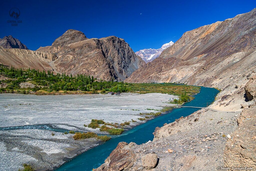
Day 5. Bulunkul – Langar (8-10 hours of driving)
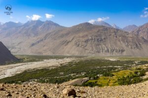
Departing Bulunkul and driving to Langar, the first settlement in the Tajik Wakhan on our way along the Pamir River via Khargush Pass (4344 m). If you are lucky, you will see Afghan caravan of camels, donkeys and horses on Afghan side across the Pamir River. In 13th century Venetian traveler Marco Polo was here on his way to China, which he marked in his book. Take photos, in some parts Afghan side is so close. Short hike to ruins of Ratm fortress watch tower (wonderful view). Kind of isolated area with wild life. Overnight in a home stay in Langar/Zong. 130km,
Meals: B/Picnic/D
Altitudes above sea level during the day: in the beginning of the day – 3737m Bulunkul, the highest point 4344m Khargush Pass. At end of the day – 2900m Langar.
Day 6. Langar – Engels meadow trek (15 mins of driving)

Engels Meadow Trek. Highlights: great view of immense Engels (6507 m) South Face. From meadow watch Hindu Kush mountain Range across the river, Tajik-Afghan border. On the back way go through another path to see Langar petroglyphs. Overnight in a homestay in Langar. 20km
Meals: B/Picnic/D
Altitudes above sea level during the day: in the beginning of the day: 2900 Langar, the highest point 3945m Engels Meadow Camp.
Day 7. Langar – Khorog (8-10 hours of driving)

Driving to Khorog. On the way visit Budha Stupa in Vrang village, the Museum of Sufi Muboraki Wakhoni, astronomer and scholar of the 19th century in Yamg, ruins of Yamchun fortresses and Qah-qah fortress (3-1 centuries BCE), soak in Bibi-Fotima hot spring and if there is time left in Garm Chashma hot spring. And see from distance the ruby mine in Sist. Overnight in a homestay in Khorog. 245km
Meals: B/L or Picnic/D
Altitudes above sea level during the day: in the beginning of the day – 2900m Langar, the highest point Yamchun fortress 3200m. At the end of the day – 2100m Khorog.
Day 8. Khorog – Barchadev (8-10 hours of driving)

Khorog city tour: Regional Museum, city park and PECTA (Pamir Eco-Cultural Tourism Association).
Departing Khorog and driving to Barchadev village of the Bartang valley. Short stops to stretch the legs and lunch in Khuf village. Overnight in a homestay in Barchidev. 210 km.
Meals: B/Picnic/D
Altitudes above sea level during the day: in the beginning of the day 2100m Khorog, at the end of the day – 2900m Barchidev.
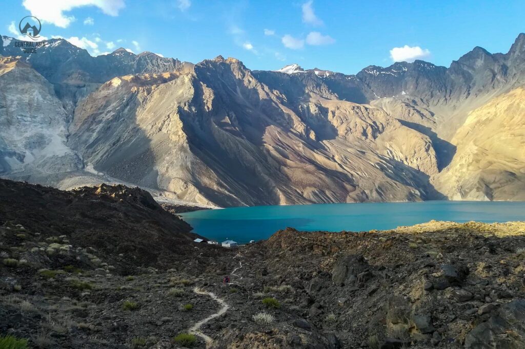
Day 9. Barchadev village - Sarez Lake.

In the morning after breakfast and proper rest, meet the local guide, who will help you with all logistics (food, accommodation and safety) during your trekking to Sarez Lake with the highest natural dam in the world 567m and back.
One day you will trek up to Sarez lake 18 km and the second day coming down from there. Usually trekking from Barchadev village to Sarez Lake dam takes 8-10 hours. It is recommended to start at 8-9 o’clock in the morning and get there before getting dark. The nature on the way is so beautiful, especially the river that flows from under the rubble of Sarez. The path in some places so narrow, take care.
On the halfway, there is a camping site – Chaykhana, where you can stop for lunch and short rest. After getting there, if it is still light, you can enjoy the beauty of the lake and around. Take pictures and talk to local people – employees of the Ministry of Emergency Situations who work at the station. Night in tent.
Altitudes above sea level during the day: in the beginning of the day – 2900m in Barchidev and end of the day 3623 meter on Usoi dam.
Day 10. Sarez Lake – Barchadev village

In the morning enjoy the beauty of the lake and take some pictures. Go down to the bank of the lake and test the water of Sarez, the water absolutely transparent and fresh. The guide will tell you the story of Lake Sarez. Coming down from Sarez to Barchadev village. Coming down is usually easier for travelers. On the way enjoy the beauty of the nature and take some pictures. The water of the Bartang River is so clean and tasty for drinking. Night in homestay in Barchadev.
Sarez Lake (Tajik: Сарез кӯл, SarezKūl) is a lake in Rushon District of Gorno-Badakhshan province, Tajikistan. Length about 75.8 kilometres (47.1 mi), max depth 505 meters, water surface elevation about 3,263 metres (10,705 ft) above sea level and volume of water is more than 16 cubic kilometres (3.8 cu mi). The mountains around rise more than 2,300 metres (7,500 ft) above the lake level.
The lake formed in 1911, after a great earthquake, when the Murghab River was blocked by a big landslide. Scientists believe that the landslide dam formed by the earthquake, known as the Usoi Dam, is unstable given local seismicity, and that the terrain below the lake is in danger of catastrophic flood if the dam were to fail during a future earthquake.[1] The Usoi Dam wall survived a localised 7.2 magnitude earthquake, the 2015 Tajikistan earthquake, on the 7th December 2015 with no visible signs of deterioration.
Altitudes above sea level during the day: in the beginning of the day 3623 meter on Usoi dam and at the end of the day in 2900m in Barchidev village.
Day 11. Barchadev – Kalai-Khumb (340km, 10-12 hours of driving)

Departing Barchidiv and driving towards Dushanbe along the Panj (Oxsus) River. Enjoying the view of the Afghan villages. Overnight in a homestay in Kalai-Khumb. 320km
Meals: B/L/D
Altitudes above sea level during the day: in the beginning of the day – 2900m Barchidev, at the end of the day – 1295m Kalai-Khumb.
Day 12. Kalai-Khumb – Dushanbe (10-12 hours of driving)

Heading to Dushanbe. Short stop to see the mausoleum of a poet and scholar of the 14th century Khoja Mir Sayid Ali Hamadani in Kulyab, Hulbuk fortress and at the viewpoint of Norak Lake Dam. Overnight in a guesthouse in Dushanbe. 355km
Meals: B/L/D
Altitudes above sea level during the day: in the beginning of the day – 1295m Kalai Khumb, the highest point Shurobod pass 2126m, at the end of the day – 780m Dushanbe.

Money & costs

Safety
Entry & exit

Best time to go

Health
Money & costs
Money & costs
Tajikistan operates on the somoni (TJS) as its official currency, although dollars are accepted in some locations. However, the somoni is the primary currency for day-to-day transactions.
Cash withdrawals from ATMs can pose challenges, so it’s recommended to carry some cash to avoid any financial inconveniences. ATMs are accessible in cities such as Dushanbe, Panjakent, Khujand, Khorog, Isfara, Istaravshan, Kurgan-Tube, and even in smaller towns, excluding Murghab.
Eskhata Bank in Dushanbe is considered a reliable option for obtaining US dollars, with a generous withdrawal limit in somoni. However, be aware that ATMs may be less available on weekends. Finding an ATM that accepts Mastercard can be a bit tricky.
Both US dollars and euros are widely acknowledged across Tajikistan. In rural areas lacking formal currency exchange services, people may prefer dollars over euros. It’s essential to note that engaging in currency exchange on the black market is illegal.
Safety
Safety
While the overall security situation is generally stable and Dushanbe is considered relatively safe, occasional incidents of robbery and petty crimes may occur. Individuals with financial resources, including foreigners, could be potential targets. Here are some further recommendations for Tajikistan:
- Always carry a copy of the photo page of your passport, as authorities may request identification.
- Exercise caution by avoiding demonstrations or large gatherings, and maintain vigilance in public spaces.
- For your safety, do not leave your drinks unattended, decline beverages from strangers, and be mindful of your alcohol consumption.
- If you experience being followed or harassed at the airport, promptly report the incident to your tour agent or the consulate office at the airport.
- Show respect for local traditions, customs, laws, and religions at all times.
- Smoking is prohibited while walking on the streets.
- The possession and use of drugs are strictly illegal.
- Women traveling alone in Tajikistan may encounter unwanted attention, harassment, or gender-related difficulties.
- Photographing anything related to the military or security services may lead to complications with local authorities.
- Same-sex sexual relationships are not illegal according to Tajikistan’s legislation. However, conservative local views and levels of tolerance may vary, especially outside major cities.
- Transportation in Tajikistan often involves poorly maintained vehicles, and driving standards are basic. Gas stations outside cities are rare, and emergency services may not be readily available. Ensure you have all necessary supplies for your trip and anticipate potential delays.
- Roads outside major cities are in poor condition and may only be accessible to four-wheel-drive vehicles. Conditions are particularly hazardous in spring due to the risk of avalanches and landslides.
- Tajikistan commonly experiences shortages of energy and water, along with frequent power outages, especially during winter and spring, mostly outside Dushanbe.
- Avoid traveling to the border area with Afghanistan due to the unstable security situation.
- Despite a ceasefire agreement, the security situation remains unstable following military clashes in the Sughd region (Northern Tajikistan), bordering Kyrgyzstan, in September 2022. Khujand is still safe to visit.
- Tajikistan is prone to earthquakes, avalanches, landslides, and floods.
Entry & exit
Entry & exit
Starting from 2022, visitors from 52 countries can enjoy visa-free travel to Tajikistan. For comprehensive visa information, refer to this link. It is crucial to leave Tajikistan before your visa or visa-free entry expires to avoid penalties and the need for an exit visa.
For those planning to explore the Gorno-Badakhshan Autonomous Region (GBAO), obtaining permission is mandatory. Keep in mind that Tajikistan’s borders might close unexpectedly. Declare large amounts of imported funds upon arrival, and when departing, present the customs declaration form.
Best time to go
Best time to go
The ideal time for exploring Tajikistan is during the spring and autumn months, specifically in April, May, June, September, and October. Summers in Tajikistan are characterized by dry and intense heat, with temperatures soaring up to 40°C in the lowlands. Winters can be extremely cold, reaching -20°C in mountainous areas, and heavy snowfall in the western region may disrupt winter routes and close high-altitude mountain passes.
September stands out as perhaps the most favorable time for a journey to Tajikistan, as the heat subsides on the plains, and nearly all but the highest mountain passes remain accessible. Markets come alive with an abundance of delicious fresh produce, and the landscape transforms into a stunning golden autumn. The best time to visit Pamir is in August.
Health
Health
Before embarking on your journey, verify that your chosen destination can offer the required medical assistance you might need. Make sure you possess suitable travel insurance covering both on-site treatment and unexpected medical evacuation. If directed to a medical facility for treatment, promptly contact your insurance provider.
Tajikistan possesses limited medical facilities and faces shortages of essential medications. Medical establishments outside Dushanbe tend to be basic, with some areas having virtually no medical infrastructure.
Certain medications containing codeine are strictly prohibited in Tajikistan. If you intend to bring medications, ensure their legality and acquaint yourself with relevant regulations. Declare all medications and other restricted items upon your arrival.
Ticks are prevalent in forests and rural areas from spring to autumn. The improper disposal of uranium and pesticides in the northern Sughd region poses potential health hazards. It is advisable to get vaccinated at least against Hepatitis A, B and Tetanus at a minimum before your trip.